Freezing rain, heavy snow and bitter cold is headed to most of the U.S. Here’s what to know.

More than 40 million Americans are under winter weather alerts on Sunday morning as a massive weather system is bringing a mix of snow, ice, and plunging temperatures. Forecasters say the dreaded combination of all three will spread eastward in the coming days.
“Winter returned,” said Bob Oravec, lead forecaster at the National Weather Service in College Park, Maryland.
The National Weather Service said more than 36 million people are under winter alerts stretching over 1500 miles from Kansas to the East Coast. Nearly 4 million people are under blizzard warnings in Kansas and Missouri.
Forecasters with the National Weather Service said Sunday that heavy snowfall and wind gusts of more than 40 mph will create blizzard conditions in parts of Kansas, Nebraska and Missouri where upwards of 15 inches – the heaviest in a decade – is expected to make travel extremely hazardous and likely impassable in some roads.
Cara Anna / AP
The polar vortex of ultra-cold air usually stays penned up around the North Pole, spinning like a top. But sometimes it escapes or stretches down to the U.S., Europe or Asia — and that’s when large numbers of people experience intense doses of cold.
Studies show a fast-warming Arctic gets some of the blame for the increase in polar vortex stretching or wandering.
The storm was forecast to move then into the Ohio Valley, with severe travel disruptions expected. It will reach the Mid-Atlantic states on Sunday into Monday, with a hard freeze even expected as far south as Florida.
Severe thunderstorms, with the possibility of tornadoes and hail, were also possible ahead of the storm system’s cold front as it crosses the Lower Mississippi Valley, the National Weather Service warned.
Parts of upstate New York saw 3 feet or more of snow from a lake effect event expected to last until late Sunday afternoon.
Some major airlines took steps to help travelers rebook scheduled flights without incurring change fees. American, Delta, Southwest and United all waived change fees for passengers due to possible weather-related flight disruptions for Mid-Atlantic travel.
Midwest prepares for the worst
For Brian Platt, city manager for Kansas City, Missouri, battling the snowstorm starts 48 hours before the first flurry.
“We’ve been pretreating the roads for two days before the storm, means we really shouldn’t get to a moment where the roads are impassable,” Platt said.
His 300 plows will clear roughly 6,400 lane miles, or the equivalent of driving from New York to Los Angeles more than twice.
“Every single plow has a tablet with a GPS mapping system,” Platt explains.
Inside the city’s snow command center, a team monitors their progress. While the technology keeps the trucks on track, the star is the salt itself. The product used is called IceBan, a magnesium chloride.
“It actually will bind to the snow particles and melt them,” Platt said. “That liquid is then much easier to remove from the streets.”
He calls it their “secret weapon.”
“We’ve never been more prepared as a city,” Platt declared. “We are absolutely ready for this, no matter what’s coming.”
Dangerous weather begins disrupting travel
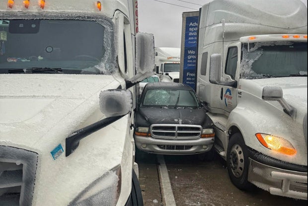
A fire truck, several tractor-trailers and passenger vehicles overturned west of Salina, Kansas. Rigs also jackknifed and went into ditches, state Highway Patrol Trooper Ben Gardner said.
He posted a video showing his boots sliding across the highway blacktop like an ice-skating rink.
“We are in it now,” Gardner said as he drove to the scene of an accident. Online, he begged for prayers and warned that some roadways were nearly impassable.
Freezing rain in Wichita, Kansas, sent authorities to multiple crashes in the morning, and police urged drivers to stay home if possible and watch out for emergency vehicles.
Governors in neighboring Missouri and nearby Arkansas declared states of emergency. Whiteout conditions threatened to make driving dangerous to impossible, forecasters warned, and heighten the risk of becoming stranded.
“Please stay off the roads. Crews are seeing too many vehicles out and sliding off,” Missouri’s transportation department said on the social platform X.
/ AP
The Kansas City International Airport temporarily halted flight operations in the afternoon due to ice. Dozens of flights were delayed, including a charter jet transporting the Kansas City Chiefs, before the runways reopened.
“Work will continue overnight to keep the airfield clear,” Mayor Quinton Lucas said in a message on X.
Freezing rain expected from eastern Kansas to the Ozarks
Dangerous sleet and freezing rain, particularly detrimental to power lines, was anticipated to start Saturday from eastern Kansas to Missouri, Illinois, Indiana and much of Kentucky and West Virginia.
Kentucky Gov. Andy Beshear declared a state of emergency on Saturday ahead of a severe winter storm system set to affect much of the state. The storm is expected to begin Sunday, Jan. 5, and bring snow, freezing rain, ice and arctic temperatures, his office said.
“This winter storm will likely cause significant disruption and dangerous conditions on our roads and could cause significant power outages – just 24 hours before it gets dangerously cold,” Beshear said.
Treacherous travel conditions are expected with power outages likely in areas with more than a quarter-inch (a half-centimeter) of ice accumulation.
“It’s going to be a mess, a potential disaster,” private meteorologist Ryan Maue said.
Frigid air from the Arctic to blast areas as far south as Florida
Starting Monday, hundreds of millions of people in the eastern two-thirds of the country will experience dangerous, bone-chilling air and wind chills, forecasters said.
New York Gov. Kathy Hochul urged New Yorkers to prepare for frigid temperatures through next week. “While we continue to respond to lake effect snow across the State, an arctic blast is expected to bring dangerously colder temperatures starting this weekend and continuing through next Friday,” Gov. Hochul said.
Temperatures could be 12 to 25 degrees Fahrenheit colder than normal as the polar vortex stretches down from the high Arctic.
“This could lead to the coldest January for the U.S. since 2011,” AccuWeather Director of Forecast Operations Dan DePodwin said Friday, noting there could be up to a week or more of “temperatures that are well below historical average.”
The biggest drop below normal is likely to be centered over the Ohio Valley, but significant and unusual cold will extend south to the Gulf Coast, said Danny Barandiaran, a meteorologist at the National Weather Service’s Climate Prediction Center.
A hard freeze is even expected in Florida, he added.
“The wind chills are going to be brutal,” Woodwell Climate Research Institute climate scientist Jennifer Francis said. “Just because the globe is warming doesn’t mean these cold snaps are going away.”
Weather may be triggered by a fast-warming Arctic
The brutal weather may be triggered in part by a fast-warming Arctic, a reminder that climate change gooses weather extremes, said Judah Cohen, seasonal forecast director at the private firm Atmospheric and Environmental Research.
The polar vortex — ultra-cold air spinning like a top — usually stays above the North Pole, but sometimes stretches down to the U.S., Europe or Asia, causing intense doses of cold.
Cohen and colleagues have published several studies showing an increase in the polar vortex stretching or wandering. Cohen and others published a study last month attributing the cold outbreaks partly to changes from an Arctic that is warming four times faster than the rest of the globe.
Related
Canada says too little, too late as Trump flip-flops on…
Nadine Yousif and Ali Abbas AhmadiBBC News, TorontoWatch: Canadian liquor store clears out US alcohol in response to tariffsNot long after the US imposed their
Vietnam, Thailand, and Philippines Among Top Asian Destinations Most-Searched by…
Home » Philippines Travel News » Vietnam, Thailand, and Philippines Among Top Asian Destinations Most-Searched by American Travelers, Driven by Surge in Viet
Trump tariffs tarnish ties: Americans anxious about travel to Canada…
Will Trump's tariffs on Canadian goods entering the U.S. affect tourism at home, tarnishing ties Canadians and Americans have shared for decades? It's a fair qu
Looming Trump travel ban strikes fear in Afghans who worked…
Expectations that President Donald Trump will soon bar Afghans and Pakistanis from entering the United States has set off panic among Afghans who were promised


